New Forest Cycling
Cycle ride 3
Woodland near Brockenhurst, including Parkhill, Pignal and Ramnor Inclosures
Start: Tilery Road car park (SU 307033).
Station: Brockenhurst, 2 kilometres.
Camping in the Forest campsite: Hollands Wood, 1 kilometre (0.6 mile).
Alternative starts:
Standing Hat car park, on the route 1 kilometre (0.6 miles) to the north-east of Tilery Road car park - by cycle track sign number 290.
Denny Wood campsite, 2 kilometres north-west of Beaulieu Road Station, is close to the route, and provides an alternative start point. Matley Wood campsite is also nearby.
Those cycling from Lyndhurst might wish to use Beechen Lane – south-east of Lyndhurst, off the A337 Lyndhurst to Brockenhurst road - to join the route close to the Park Pale in Parkhill Inclosure.
Distance: 11 kilometres (7 miles), all off-road.
Extend or shorten the route: To optionally increase the distance covered, combine this cycle ride with nearby Cycle ride 4 (to the south-east of this ride). Alternatively, to reduce the distance covered, take any of the cycle route shortcuts shown in yellow on the map.

Based on the large block of woodland in the centre of the New Forest, near Brockenhurst, this cycle ride is largely on level ground with few significant gradients.
The start point is the Tilery Road car park, close to the ever-imposing Balmer Lawn Hotel, a building with an impressive history as a First World War hospital and Second World War, Army Staff College and planning base. Alternative starts are available at Standing Hat, Denny Wood and on the outskirts of Lyndhurst. The Hollands Wood camp site, another alternative start point, is also only a relatively short distance away.
A wide range of pubs, tea rooms, cafes and shops can be found in Brockenhurst as can a railway station for those travelling into the area by train.
Tilery Road is well-named for, although simply a wide, compacted track rather than a road in modern terms, it was the main access route to the Victoria Brick and Tile Works, a manufacturing facility built in the mid-19th century to produce tile-pipes used to drain below-the-surface water and deposit it into specially cut, open channels that today still crisscross many New Forest lawns. The tile works ceased to operate in the first quarter of the 20th century and its location is today marked by a still-occupied house and associated outbuildings.
Further historical interest along the way is provided by a very brief encounter with the Park Pale, an, in places, substantial earthen bank with accompanying ditch dating back to at least the 13th century - it once surrounded a medieval deer park: what was to become known as Lyndhurst Old Park.
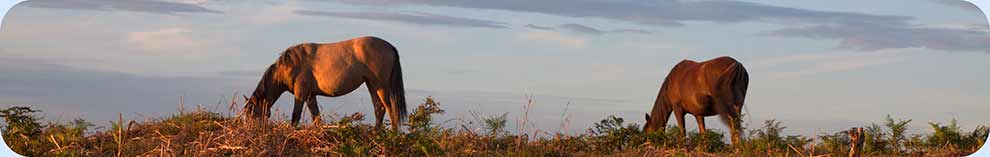
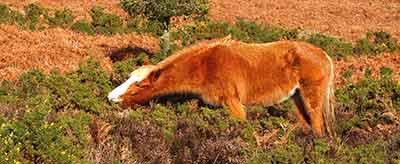
Before plunging into woodland, the route crosses beside Balmer Lawn, an extensive area of grassland dotted in places by hummocks once thought to be intensely grazed purple moor grass tussocks but now thought be the remains of yellow meadow ants' nests. Quite deep drainage channels cut into the lawn provide homes for dragonflies and damselflies, whist fallow deer and roe deer can sometimes be seen grazing out in the open, although they more often remain close to the woodland edge, ready to melt into cover at any perceived threat of danger.
The inclosure woodlands, created along this route between 1750 and 1866, are extremely varied and feature a range of attractive, mature broadleaved trees, such as oak and beech, and an equally varied selection of large conifers including occasional, impressively tall, ornamental ride-side Douglas firs. Beautiful ancient, unenclosed woodland is also featured along the way, in the area to the north and west of Denny Lodge - notice the presence of large numbers of obviously ancient trees; their random, entirely natural spacing; and the delightful clearings created where giants of yesteryear have fallen and not been replaced.
Wildlife, including a range of woodland birds, may be encountered throughout this cycle ride, but of particular note are the meadows to the south of Denny Lodge, for there can sometimes be seen outside the rutting period a herd of fallow bucks with antlers in varying stages of re-growth. The Frohawk Ride is also worthy of mention. This fairly modest, bramble-lined path was designated in 1995 to commemorate the celebrated naturalist Frederick William Frohawk (1861-1946), an eminent butterfly expert, general naturalist and artist, who was a regular visitor to the New Forest. (Look out in May and the first half of June for the rather scarce, pearl-bordered fritillary butterfly, and from April until early October for a variety of other woodland butterflies, including white admirals, speckled woods and silver-washed fritillaries).
The route
(Only designated cycle tracks are usually mentioned below and shown on the map (as yellow lines), not footpaths and other tracks. Cycle route marker post numbers are also shown).
1) Leave the car park and turn left to take the gravel track leading north-east towards Standing Hat.
2) Pass alongside the Standing Hat car park, ignore a cycle track to the right, and almost immediately go through a gate. Take the left-hand cycle track through Pignal Inclosure.
3) After 0.5 kilometres (1/3 mile), follow the track as it goes to the left, then shortly after, leave Pignal Inclosure and follow the track as it goes 90 degrees left to run between Pignal and Ramnor Inclosures. After another 0.5 kilometres, follow the track 90 degrees to the right, into Ramnor Inclosure.
4) Reach a ‘Y’ junction after a further 0.5 kilometres, and take the track downhill to the right, then after a similar distance, as the track swings left, leave Ramnor and enter Parkhill Inclosure.
5) After a very short uphill stretch, follow the track as it turns 90 degrees to the right, then turn left at a junction - cycle ride sign number 272 – opposite the Frohawk Ride.
6) After 0.5 kilometres, pass a number of huge ornamental conifers at the edge of the woodland to the left, reach a ‘Y’ junction and go to the right. Pass another small group of ornamental conifers, continue uphill and then turn sharp right, downhill, at a ‘T’ junction. (Opposite the ‘T’ junction, the Park Pale can be seen as a wasted bank and accompanying ditch running parallel to the track, 15 metres, or so, into the wood).
7) After 0.75 kilometres (1/2 mile), reach another junction at the other end of the Frohawk Ride, turn sharp left, and continue, eventually uphill, for 1 kilometre.
8) Leave Parkhill Inclosure through a gate, and enter the magnificent ancient, unenclosed woodlands of Denny Wood - notice here the haphazard, natural placement of the trees, contrasting sharply with the adjacent, regimented inclosure plantings.
9) On the left can be seen the corner of Denny Inclosure. Follow the track here as it swings round to the right, and then, after 0.3 kilometres (1/5 mile), turn right at the next ‘T’ junction, onto the tarmac road leading towards Denny Lodge. (This is the road from Denny Wood camp site. A sign here warns motorists that there is ‘Access to Private Properties only)’.
10) Continue straight ahead, past two rather odd-looking man-made mounds on the right of the track, then follow the track as it goes left, downhill, past the white-washed bungalow that is Denny Cottage. (Look out for fallow deer in the meadows beyond the cottage – this is a favourite feeding and lying up area).
11) Go through the gate into inclosure woodland, and continue along the track for just over 0.5 kilometres. (This is presumably Parkhill Inclosure again, although the Ordnance Survey map does not make this particularly clear).
12) Pass a gravel track on the left – it is not a cycle track – and shortly after, notice on the right, a corner of Stubby Copse Inclosure. Continue on for a short distance to pass a cycle track going off to the right.
13) After a further 0.5 kilometres, turn right at a ‘X’ roads – cycle track sign number 324, but note, the left turn is not a cycle track – and then follow beside Perrywood Haseley Inclosure.
14) After 1 kilometre, reach a ‘X’ roads and go straight ahead - cycle track sign number 305. Follow the track first left and then right into Pignalhill Inclosure, pass Victoria Tilery Cottage on the left, go through a gate and on into the area adjacent to the car park at Standing Hat.
15) Turn left at the ‘T’ junction, and return alongside Balmer Lawn to the Tilery Road car park.
Quick linksMore links
Search this site
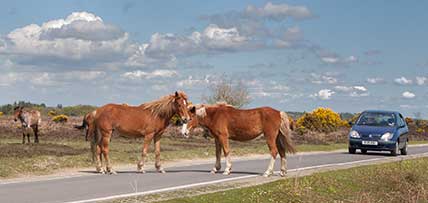
Sadly, 58 animals were killed - 35 ponies, 13 cows, 8 donkeys and 2 sheep, whilst a further 32 were injured - 3 pigs, 9 donkeys, 11 cows and 9 ponies.
(Forty-three accidents occurred in daylight, 15 at twilight and 101 in the dark. Twenty-seven accidents were not reported by the driver involved).
Here's just one horrific example - Three donkeys killed in collision with van at notorious New Forest blackspot (Advertiser and Times)